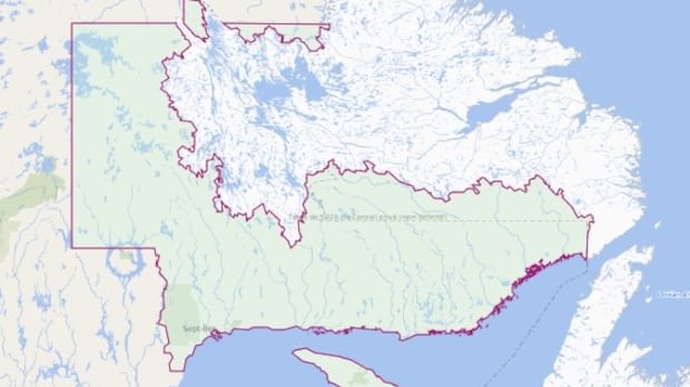
Quebec’s Duplessis riding, situated in the vast Côte-Nord region, may not immediately catch the attention of most Quebec residents despite being the province’s second-largest riding by land area. With a sparse population, the riding is home to 37,073 registered voters out of a total population of over 48,000, mainly concentrated in Sept-Îles and Port-Cartier. However, a closer examination of the riding’s boundaries, depicted on Élections Québec’s electoral map, highlights a longstanding issue concerning Quebec.
The electoral map, also utilized by various media outlets, including CBC News, encompasses a section of southern Labrador, portraying it as part of Quebec. According to Gabriel Sauvé-Lesiège, spokesperson for Élections Québec, this inclusion stems from a historical dispute dating back nearly a century. In 1927, the Privy Council in London delineated a boundary between Quebec and Newfoundland and Labrador, a decision never formally acknowledged by Quebec governments. Hence, any official map of Quebec features this contested territory.
The boundary ruling favored Labrador during a dispute between Quebec and Newfoundland in 1927, establishing the land border far inland, encompassing the entire water basin of rivers flowing into the Atlantic Ocean. This decision, entrenched in the Canadian Constitution upon Newfoundland’s entry into Canada in 1949, remains a point of contention reflected on Quebec’s maps.
Regarding voter eligibility in the Duplessis riding, questions arise about residents domiciled in Newfoundland and Labrador within the riding’s limits. Élections Québec notes that as no individuals residing in this territory are currently registered on Quebec’s electoral list, hypothetical scenarios require thorough analysis.
Kathryn Furlong, a geography professor at the University of Montreal, views the inclusion of Labrador in the riding as a political statement rather than practical voting representation. This disputed portion of Labrador, termed “ultra petita” by Furlong, was granted to Newfoundland in the 1927 border decision, despite not being initially requested.
The border dispute involving Labrador, particularly its hydroelectric potential along the southern border, has been a longstanding issue due to its economic significance. Quebec’s policy of non-recognition, symbolized by a “non-definitive” border on provincial maps, serves as a tool for political and economic leverage in negotiations and nationalist sentiments.
In a recent policy document, the Parti Québécois outlined intentions for redress on the border issue within the context of Quebec’s sovereignty aspirations. While legal challenges may be limited, the party proposes political settlements or financial compensation as potential resolutions. Furlong emphasizes the aggressive nature of the discourse surrounding the border, especially for Labrador residents caught between Newfoundland and Quebec interests.
As the border issue resurfaces during elections, Newfoundland and Labrador Premier Tony Wakeham maintains that the matter is settled and not open for debate, emphasizing the clear and recognized borders of the province.